
Fort Myers Beach Zoning Maps
After forty years of zoning administered by Lee County (FL), the Town of Fort Myers Beach retained Spikowski Planning in 2004 to create a entirely new zoning map to accompany the new Land Development Code.
This map contains conventional zoning districts for its stable neighborhoods, form-based zoning districts for its redevelopment areas. Obsolete zoning actions were transferred to a separate “historic” zoning map for reference purposes.
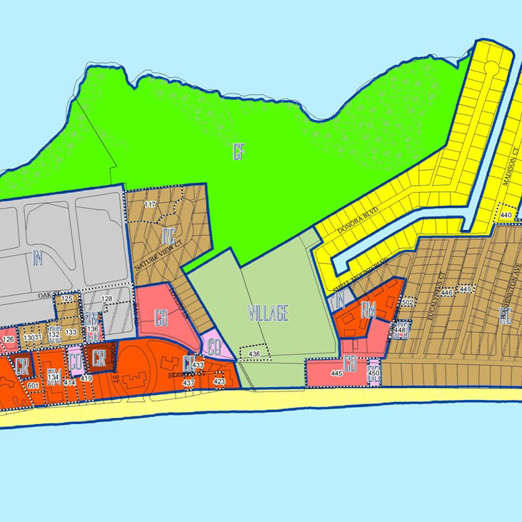
On May 17, 2004, the Town Council approved two resolutions that adopted "official" and "historic" zoning maps for the entire town. These maps are the result of the new zoning chapter (chapter 34) of the town’s land development code, which was adopted by Ordinance 03-03 on March 3, 2003 to implement the town’s 1999 Comprehensive Plan. Background memos are now available that explain both maps and contain attachments with drafts of resolutions and reproducible copies of the maps.
The final adopted resolutions are available by clicking below:
Resolution 04-16 -- Adopting an Official Zoning Map for the Town of Fort Myers Beach
Resolution 04-17 -- Adopting a Historic Zoning Map for the Town of Fort Myers Beach
Ordinance 03-03 adopted an "interim" zoning map that assigned new zoning districts to all land in the town. The new "official" zoning map uses the same zoning districts as assigned by Ordinance 03-03 but adds relevant variances, special exceptions, special permits, rezonings, and similar approvals that were approved by resolution through April 1, 2004. The conversion of the "interim" zoning map into the "official" zoning map is mandated by Section 34-614 of the town’s land development code. The official zoning map includes key numbers that are explained by detailed notes that provide a record and index of variances, special exceptions, special permits, and similar approvals.
The new "historic" zoning map shows the zoning districts that applied to all properties immediately prior to the adoption of Ordinance 03-03 and all variances, special exceptions, special permits, and similar approvals that had been approved by Lee County or the Town of Fort Myers Beach prior to the adoption of Ordinance 03-03. This map provides a historic record of past zoning actions and prior zoning status that may affect the nonconforming status of certain properties within the town. The historic zoning map also includes key numbers that are explained by detailed notes that provide a history of prior rezonings, variances, special exceptions, special permits, and similar approvals that had been approved before Ordinance 03-03 was adopted on March 3, 2003.
Both of these maps can also be downloaded in files that permit them to be printed out in full color for wall mounting (up to 36" by 48"). The key numbers refer to the same index of variances and special exceptions in the resolutions.
- "Official zoning map" (wall-sized map only)
- Reprint of official zoning map (color wall map, without notes)
- "Historic zoning map" (wall-sized map only)
![]()
Map Archive
- Map of land values at Fort Myers Beach (10-30-96)
- Map with old and new Coastal Construction Control Lines and current flood insurance boundaries (6-20-02)
- FUTURE LAND USE MAPS:
- As originally adopted (1-1-99)
- Wall map (reflecting original adoption) (1-1-99)
- With latest revisions (7-22-04)
- ZONING MAPS:
- Interim zoning map (3-3-03)
- Official zoning map (with all notes, Resolution 04-16) (5-17-04)
- Official zoning map (color wall map, without notes) (5-17-04)
- Reprint of official zoning map (color wall map, without notes)
- Historic zoning map (with all notes, Resolution 04-17) (5-17-04)
- Historic zoning map (color wall map, without notes) (5-17-04)
![]()
For everything else you might want to know about the Town of Fort Myers Beach, visit their web site.