
Land Use Scenarios for Lee County MPO
SUMMARY: Three land use scenarios for the year 2040 were evaluated by the Lee County (FL) Metropolitan Planning Organization for their potential to reduce trip lengths and increase transit viability. In June 2014, the MPO selected a preferred scenario as the basis for the upcoming long-range transportation plan. Spikowski Planning and Criterion Planners worked with Jacobs Engineering and city/county planners to formulate and analyze the scenarios.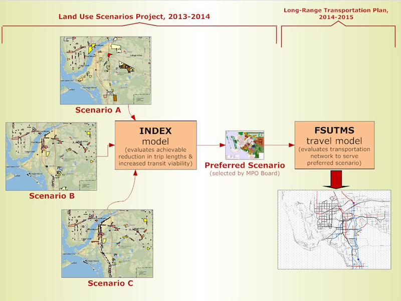
OVERVIEW: The Lee County Metropolitan Planning Organization (MPO) has completed an intensive effort to explore alternative ways the county could grow in order to reduce vehicle trips and increase travel options. Identifying future land use patterns as alternative scenarios has allowed the MPO and citizens of Lee County to evaluate the costs and benefits of different patterns. In June 2014, the MPO Board selected Scenario C, which will become the basis of the future transportation vision in the MPO’s forthcoming 2040 Long Range Transportation Plan (LRTP), which must be adopted by December 2015.
Understanding the potential locations of
future concentrations of housing and jobs helped create the
alternative scenarios. Much of the analysis has been completed using the
INDEX land use model which has an integrated database that can assess
key indicators such as vehicle miles traveled, densities, and energy
consumption. All the local government staffs in Lee County were
involved throughout the process of formulating alternative growth
scenarios to incorporate the latest local planning efforts.
Coordination among stakeholders, local agencies, the general public, the MPO Committees, and the MPO Board has occured throughout scenario development, comparison of alternatives, and selection of the preferred scenario. This has included presentation of documents, policy assumptions, and future projections.
The MPO retained Jacobs Engineering Group to coordinate this effort. Jacobs was assisted by Spikowski Planning Associates and Criterion Planners.
-
-
Appendix A to final report -- Public Engagement Report (January 2015)
-
Download data in GIS format (fields names are defined in the final report)
-
Download data in Excel format (fields names are defined in the final report)
-
·
Ned Baier, Jacobs Engineering Group (813) 746-3396
ned.baier@jacobs.com
·
Bill Spikowski, Spikowski Planning Associates (239)
334-8866 bill@spikowski.com
·
Don Scott, Lee MPO Executive Director (239) 330-2241
dscott@leempo.com
Please provide any comments to any of the
above contacts. Mail can be sent to:
Ned Baier, Project Manager
JACOBS
201 N. Franklin Street, Suite 1400
Tampa, Florida 33602